Remembering the 1963 Canada Trip
In July of 1963, our family went on a camping trip through Canada. In one of the home movies, my dad filmed the date, and I have a brother Tom who remembers the trip as well. What I thought would be fun is retrace the trip by identifying the places in the videos (converted home movies). I split the trip into 8 small clips, each about one minute long. This is at the end of Clip 8 showing the trip info:

This post will discuss the first three clips. I am not including the clips here but I have shared them on my FaceBook Wall. I have included some screen captures of the clips as well as screen captures from Google Earth.
I know we started in Middlebury Vermont, and the whole family went including my sister Patsy (age 15), my brother John (age 12), my brother Tom (age 8), and of course me (age 5). My dad Harold was 40 and mom had just turned 35. Camping is what we did...


Of course, the next scene in the home movie is of the Chateau:


...and here is the Chateau Frontenac in the winter with people using the toboggan run:

The next scene is the family climbing some stairs which I assume is still at the Chateau Frontenac. My friend Sally liked that dad is holding my hand as we climb. John and Tom are just going fast and sister Pat is using the handrail. Mom must be the film-maker.

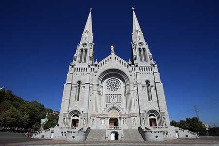
The rest of the clip is of a large cathedral which people helped me identify as the Basilica of St Anne de Beaupre. Here is a screen capture followed by a photo from the Internet. The town is called St Anne de Beaupre and has a population of 2,803. It is located about 30 miles East of Quebec City on the Saint Lawrence River.


That ends the first clip...

Then we stop again to camp in an unknown location. The tent and canopy look great with me (I think) standing next to the setup. I always loved that we had a tent you could walk into standing up. But I guess at my age, that could have been a pup tent as well. But I mean the adults...

Then we are at a beach that is rocky. You can see John, Tom and I climbing over the rocks, with tidal pools all around. I am sure we are still on the Saint Lawrence River because of the last scene in the clip.

Pat is holding a starfish and the clip includes a close-up of Tom holding a starfish too. So, I have an unidentified rocky beach on the Gaspe peninsula that has starfish. No luck with my Google search for this location.


There is no roadway where our tent was staked, so I had to get to the closest road points. The yellow building looks very similar to the one that is in the movie, but the chimney is different. In this Google Earth street view, Perce Rock can be seen in the distance, to the right of the house.

In this Google Earth street view, Perce Rock can be seen to the left of the same house at an observation point. I do not think that was there in 1963.


The building is yellow but in the current Google Earth, the little cabins are gone. I do want to mention the big green box in the back of the Rambler. I mentioned that we camped a lot and dad created this box as a pantry. Stored in it were all the utensils, napkins, and cooking pans, as well as condiments and seasonings. It had lots of storage areas and was pretty creative. The door opened down with chains holding it in place. The door than became a table to lay things out on. If we were staying at a place for more than a night or two, we moved the box from the car to the end of the picnic table under the canopy. I am not sure what happened to it, but we used it on many trips.

The car is next to our tent, and in a Google Earth street view, I was able to capture the same cliff from the movie, even with picnic tables.

The third clip ends with me running toward the camera. Tom is behind me and John is hiding under the canopy, you can see his legs.


This post will discuss the first three clips. I am not including the clips here but I have shared them on my FaceBook Wall. I have included some screen captures of the clips as well as screen captures from Google Earth.
I know we started in Middlebury Vermont, and the whole family went including my sister Patsy (age 15), my brother John (age 12), my brother Tom (age 8), and of course me (age 5). My dad Harold was 40 and mom had just turned 35. Camping is what we did...
Home Movie Clip 1 - 1963Canada01
The opening clip is of my sister Pat and I in front of our camp including the big green Army tent and our famous orange and blue canopy. Dad is sitting at the picnic table behind us and I know this campsite must be between Vermont and Quebec City (see map). Middlebury is located just left and below the V in Vermont.

I know that the Provoncha (Provencher) family came out of the Trois-Rivieres area so we may have been camping there. The next scene is a large ship on the Saint Lawrence River which is one of the three rivers that meet.
Then we arrive in Quebec City. The first scene is of a monument to Samuel de Champlain, who found the lake that bears his name along the western border of Vermont. From the clip:

The monument can be easily found on the Internet, as it is located in front of the Chateau Frontenac in Quebec City. An image from the Internet:

Of course, the next scene in the home movie is of the Chateau:

And then there is a scene of my dad with Tom and I. We are standing in what I figured out was a toboggan run. It must have been chilly since we all have on sweaters. Here is a screen capture of the clip:

...and here is the Chateau Frontenac in the winter with people using the toboggan run:

The next scene is the family climbing some stairs which I assume is still at the Chateau Frontenac. My friend Sally liked that dad is holding my hand as we climb. John and Tom are just going fast and sister Pat is using the handrail. Mom must be the film-maker.

The rest of the clip is of a large cathedral which people helped me identify as the Basilica of St Anne de Beaupre. Here is a screen capture followed by a photo from the Internet. The town is called St Anne de Beaupre and has a population of 2,803. It is located about 30 miles East of Quebec City on the Saint Lawrence River.

That ends the first clip...
Home Movie Clip 2 - 1963Canada02
The opening scene is of some islands in the Saint Lawrence River. I could not find them on Google Earth with the same buildings so I have not included it here.
Then there is a very short image of another church. I have not been able to identify it yet.

Then we stop again to camp in an unknown location. The tent and canopy look great with me (I think) standing next to the setup. I always loved that we had a tent you could walk into standing up. But I guess at my age, that could have been a pup tent as well. But I mean the adults...

Then we are at a beach that is rocky. You can see John, Tom and I climbing over the rocks, with tidal pools all around. I am sure we are still on the Saint Lawrence River because of the last scene in the clip.

Pat is holding a starfish and the clip includes a close-up of Tom holding a starfish too. So, I have an unidentified rocky beach on the Gaspe peninsula that has starfish. No luck with my Google search for this location.

At the end of this clip, Dad (or mom) was capturing some rugged cliffs as we drove along the road. Here is a screen image from the clip, it was a little bit foggy:

To identify the location, I did a Google search on "cliffs along the road in Gaspe Quebec". I looked at the results as images. Most of the hits were of Perce Rock (see Clip 3) but there was this one image of a postcard with cliffs along a highway.

Wow, a rugged corner at Gros Morne on the Gaspe Highway in Quebec. I went to Google Earth and found the cliffs outside of the small town of Gros Morne. In street view, I captured this image:

It sure looks like the same spot. So at the end of clip 2, we had reached Gros Morne in Quebec, right on the top end of the Gaspe Penisula. I am assuming that all previous scenes were between St Anne de Beaupre and Gros Morne.

Home Movie Clip 3 - 1963Canada03
The third clip starts with our camp with Perce Rock right behind us. Our light green Rambler next to the canopy. Flying, what looks like out of our tent, is the official flag of Quebec...


Perce Rock is located on the East end of the Gaspe Peninsula in the province of Quebec. Here is a map from Google Earth.


In this Google Earth street view, Perce Rock can be seen to the left of the same house at an observation point. I do not think that was there in 1963.

The clip captures some more of our camp and the scenery away from Perce Rock. Here is the capture of the home movie clip:

The building is yellow but in the current Google Earth, the little cabins are gone. I do want to mention the big green box in the back of the Rambler. I mentioned that we camped a lot and dad created this box as a pantry. Stored in it were all the utensils, napkins, and cooking pans, as well as condiments and seasonings. It had lots of storage areas and was pretty creative. The door opened down with chains holding it in place. The door than became a table to lay things out on. If we were staying at a place for more than a night or two, we moved the box from the car to the end of the picnic table under the canopy. I am not sure what happened to it, but we used it on many trips.

The car is next to our tent, and in a Google Earth street view, I was able to capture the same cliff from the movie, even with picnic tables.

The third clip ends with me running toward the camera. Tom is behind me and John is hiding under the canopy, you can see his legs.

Next post I plan to continue the discussion of our 1963 Canada trip. Perce rock will be revealed in all its glory!


Again, a winner!
ReplyDelete